What is a digital farm map?
AirAgri is able to aid farmers in the management of their lands by producing accurate farm maps. These maps may be found on their website.
The farming of today requires the keeping of records that are exhaustive and precise in nature.
Farm maps are a useful tool that can assist with achieving this objective in a manner that is not only understandable but also accurate.
Available throughout the entirety of Australia for public consumption.
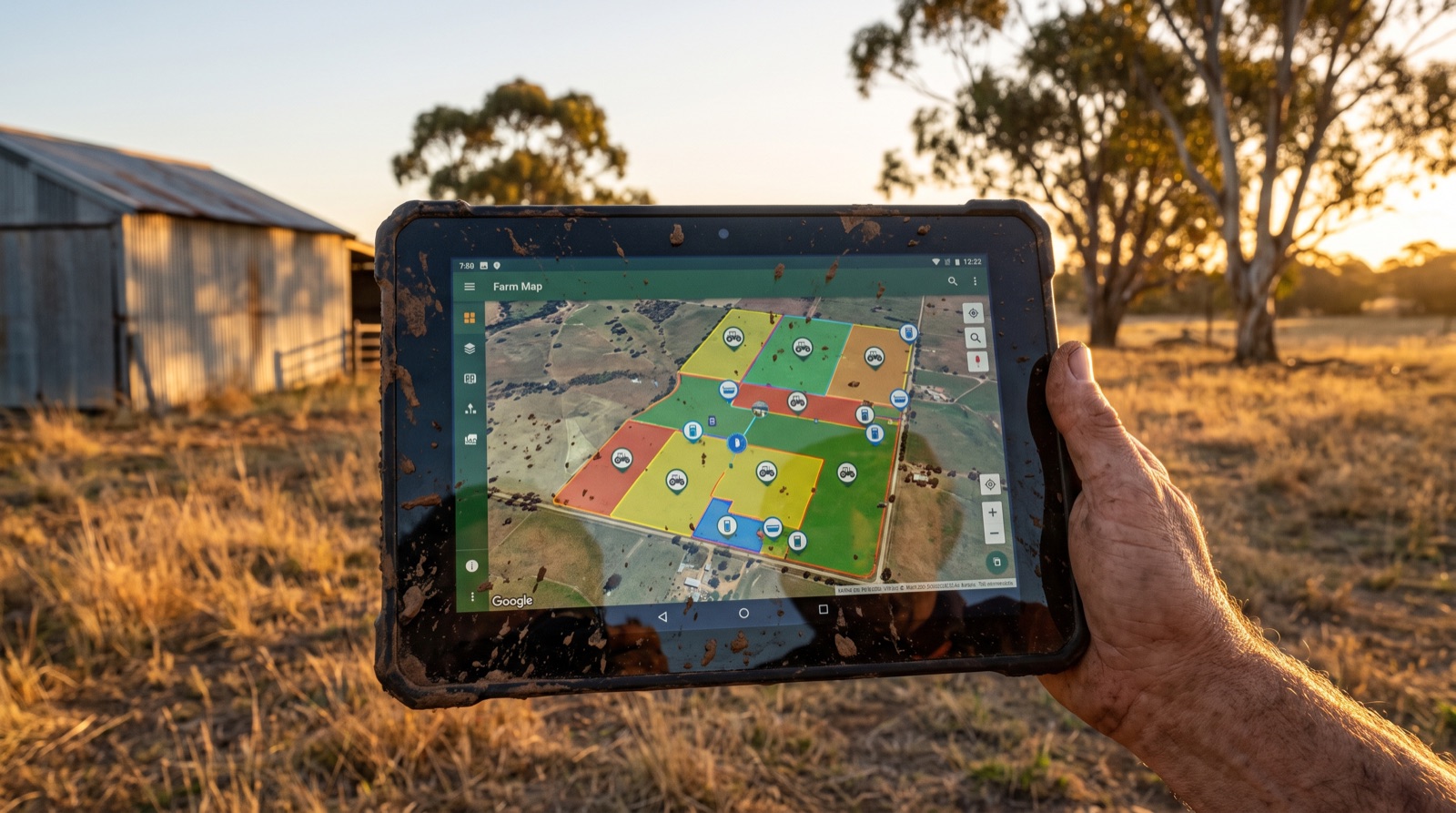
Paddock records can be preserved that are easy to understand and can be utilised for a variety of purposes with the assistance of an accurate digital farm map that was developed by AirAgri.
- Irrigation
- Fertiliser use
- Feed budgeting
- The recording of stock
- Planning for the entire farm
- QA, quality assurance purposes
- Utilisation of sprays and chemicals
- Charting the development of the pasture
AirAgri is able to produce maps that are suitable for use in agricultural computer systems since they may be saved in either the MIF or JPEG file formats, both of which are compatible with one other.
Through the use of the maps that are generated by AirAgri, it is possible to piece together, over the course of time, a history of the farm that is both exhaustive and easily understood. This history can then be put to use for the planning of the farm as well as the generation of reports for quality assurance, financial planning, and a number of other purposes.
GIS Maps for Agriculture
The technologies of Geographic Information Systems (GIS), Global Positioning Systems (GPS), and Satellite Imaging can be of tremendous assistance to farmers and growers in the process of accumulating vital information that can be used to monitor and manage crops, yields, soil, and vegetation. The technologies of geographic information systems (GIS) and satellite imaging collect data to provide precision agricultural mapping for farmers and growers. This allows farmers and growers to support crop production and control any hazards on their farms.
Mapping for Accurate Agriculture Precision
Satellite sensors with medium and high resolution can collect data to study crops and soil using green vegetation index maps, such as the Normalised Difference Vegetation Index (NDVI), to build yield and soil index maps. This data can be used to produce yield and soil index maps. The use of this data can assist farmers and growers in successfully monitoring and managing their fields in order to produce crops. Farmers and growers can benefit from satellite imagery and GIS data by gaining a better understanding of what is occurring on the ground in real-time. This understanding can assist with the analysis of soil health, climate change, disease management, and pest control, as well as provide information for improved farming, crop protection, and getting the job done more quickly.
Farmers and growers need information on their fields, and soil analysis is essential so that their farms can continue to thrive and bring in a higher return on investment.
Soil Zone Maps
You may get a good picture of the variances in the landscape by using a soil zone map. Lighter colours represent soils that are dry, salty, or have a coarse texture, while darker hues suggest soils that are damp or organic. Variations in colour often reflect topographic differences across fields, which can significantly influence your crop management techniques and the generation of zone maps for precision agricultural management applications.
Crop Yield
You may routinely and statistically monitor vegetation, crop yields, status, and variation across your property with satellite images and GIS data. This allows you to better manage your crops throughout the season and to move backward in time to find reasons that may be restricting your production.
A farm mapping software is essential for modern farmers as it provides comprehensive and accurate records, assists in various farm management tasks, and integrates advanced technologies like GIS and satellite imaging. With features such as paddock record preservation, irrigation and fertiliser management, stock recording, and crop planning, it enables farmers to make informed decisions for optimising their agricultural practices. Additionally, by utilising satellite imagery and GIS data, farmers can monitor soil health, vegetation status, and crop yields in real-time, allowing for effective disease management, pest control, and improved farming techniques. Overall, a farm mapping software streamlines farm operations, enhances productivity, and ensures sustainable and efficient farming practices.